Seaside Lights

SeaSide Lights

  | Latest Changes | Features | Accommodation | Show State Listing | Show State Map
Select a State
Search

 · Cape Liptrap
 · Cape Nelson
 · Cape Otway
 · Cape Schanck
 · Citadel Island
 · Cliffy Island
 · Coles Light
 · Gabo Island
 · Gellibrand light
 · Griffith Island
 · Lady Bay Lower
 · Lady Bay Upper
 · McCrae Lighthouse
 · Point Hicks
 · Point Lonsdale
 · Port Melbourne
 · Queenscliff Black
 · Queenscliff White
 · Schnapper Point
 · South Channel Pile
 · Split Point
 · St Kilda Marina
 · West Channel
 · Whalers Bluff
 · Williamstown Timeball
 · Wilsons Promontory


Subscribe to
Lighthouses-Australia

RSS Feeds
Lighthouse News Feed Lighthouse News
SeasideLights Photography Feed Seaside Lights Photography

Williamstown Timeball

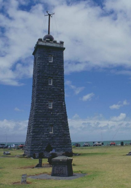
The Lighthouse was erected in 1852, and replaced earlier navigational aids established from the time of the first settlement in 1835. A Timeball apparatus mounted on top of the bluestone tower operated regularly until 1926. 

The Timeball Tower is situated at Point Gellibrand, Williamstown. Its original use was as a signalling device to ships. From 1858 until 1926 the large ball on the top was dropped each afternoon at one o'clock to allow shipmasters moored offshore to correct their chronometers.

In 1932 it was adapted for use as a lighthouse by the addition of a 30ft circular brick tower and it operated as such until 1987. The Williamstown Historical Society has recently had the brickwork removed and the restored to its original design.


Williamstown Timeball Tower

Technical / Historical Details
Nearest Town   Height - Elevation 17.1m (56ft) - 22.3m (73ft) 
Lat/Long: 38°35 143°20  Lantern  
Construction Square bluestone tower  Lens N/A 
Built 1849  Character  
First Lit   Range NM  
Automated      
De-activated   Open Grounds only 
Architect   Access Road 
Reference   Accommodation No 
See Also: Semaphore Timeball 
Sources:  
Other Links:    


 © 1999-2024 Garry Searle      No part of this site may be used without permission.